West Coast Wilderness Trail: Greymouth to Ross Great Ride Guide
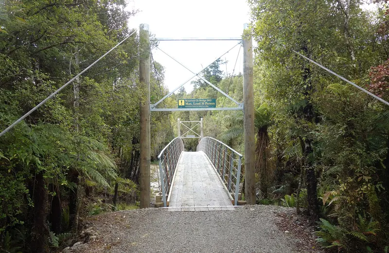
Photo: “West Coast Wilderness Trail 180” by Schwede66, CC BY-SA 4.0, via Wikimedia Commons
Trail at a glance
- Type
- Great Ride
- Region
- West Coast
- Distance
- About 136 km
- Time
- 4 days
- Grade
- Grade 2 (easy)
- Bookings
- Not required
- Managed by
- Ngā Haerenga NZ Cycle Trail
Overview
The West Coast Wilderness Trail runs from Greymouth's historic port to the old gold town of Ross. It passes rainforest, pristine rivers, tranquil lakes and rugged beaches, with the snow-capped Southern Alps as a backdrop. Along the way it uses old packhorse tracks, tramlines, railways, gold-miners' water races and historic bridges, all tied together with flowing singletrack.
It's an easy (Grade 2) ride, wide and smooth most of the way, and suits beginners up. The four sections add up to about 136 km, each taking 3–5 hours. Autumn and winter, with crisp, clear air and snow on the Alps, are a great time to ride.
Current alert
Totara Bridge is closed because of its structural condition, near the end of the trail before Ross. You can ride to it from either side but can't cross. Many riders finish at the Treetop Walk or ride the old rail line to the bridge and back. Competent riders can continue to Ross on the road with extreme care; children shouldn't. Check the trail website for updates.
Highlights
- Wetlands and scenic reserves, with Alps views
- Shantytown Heritage Park, a 6.5 km return detour
- Kumara's restored Theatre Royal Hotel
- The Loopline Reservoir, with a stone dam hand-laid in 1883
- Lake Kaniere and the Kaniere Water Race (1875)
- The Mahinapua tramway, boat cruise and kayaking, and the West Coast Treetop Walk
- Pounamu and glass studios in Hokitika, and gold panning in Ross
Trail sections
| Section | Distance | Grade | Time |
|---|---|---|---|
| Greymouth → Kumara | 31 km | 2 | 2–4 hr |
| Kumara → Milltown | 36 km | 2–3 | 3–6 hr |
| Milltown → Hokitika | 36 km | 2–3 | 3–5 hr |
| Hokitika → Ross | 33 km | 2–3 | 3–5 hr |
- Kumara → Milltown has the only real climb: a gentle 317 m to Kawhaka Pass, then a descent through virgin rainforest. Mobile coverage is patchy, so pre-arrange shuttles.
- Hokitika → Ross is particularly flat, and great for beginners and families as far as the Treetop Walk.
- The on-road sections are rated Grade 3.
Day rides
| Ride | Distance | Time |
|---|---|---|
| Mahinapua Magic (Hokitika → Treetop Walk) | 15 km | ~2 hr + stops |
| Kumara Gold Trails (Kawhaka Intake → Greymouth) | 45 km | ~4 hr |
| Majestic Forests & Lake (Kawhaka Intake → Hokitika) | 49 km | 6–7 hr |
Need to know
- Bike: A hybrid is enough. E-bikes are allowed.
- Weather: Milder and sunnier than its reputation, but floods and washouts happen, so check the trail website and ask locals.
- Camping: Strictly no camping on the trail itself. Use the designated campgrounds, including the DOC site at Lake Kaniere.
- Mobile coverage: Good in towns and along much of the coast. Virtually none from south of Kumara to Kaniere.
- Dogs and horses: Not allowed. The trail crosses conservation land, penguin colonies and farmland.
Getting there
Greymouth is about 4 hours from Christchurch over Arthur's Pass, or take the TranzAlpine train. Hokitika has an airport. Bike hire, shuttles and luggage transfers are based in Greymouth and Hokitika. Book ahead for December to March. The official guidebook is sold along the trail.
Route map
The line shows the West Coast Wilderness Trail as mapped in OpenStreetMap. It measures about 135.8 km, against an official distance of About 136 km. Use it to see where the route goes. It isn't for navigation, so carry the official map and check track status with Ngā Haerenga NZ Cycle Trail (opens in a new tab) before you set out.
Location data: OpenStreetMap contributors (ODbL 1.0).
Check before you go
Closures, slips, snow and booking changes happen often. Ngā Haerenga NZ Cycle Trail posts current alerts and bookings for the West Coast Wilderness Trail on its official page.
Current alerts and bookings