Pou Herenga Tai Twin Coast Cycle Trail: Bay of Islands to Hokianga
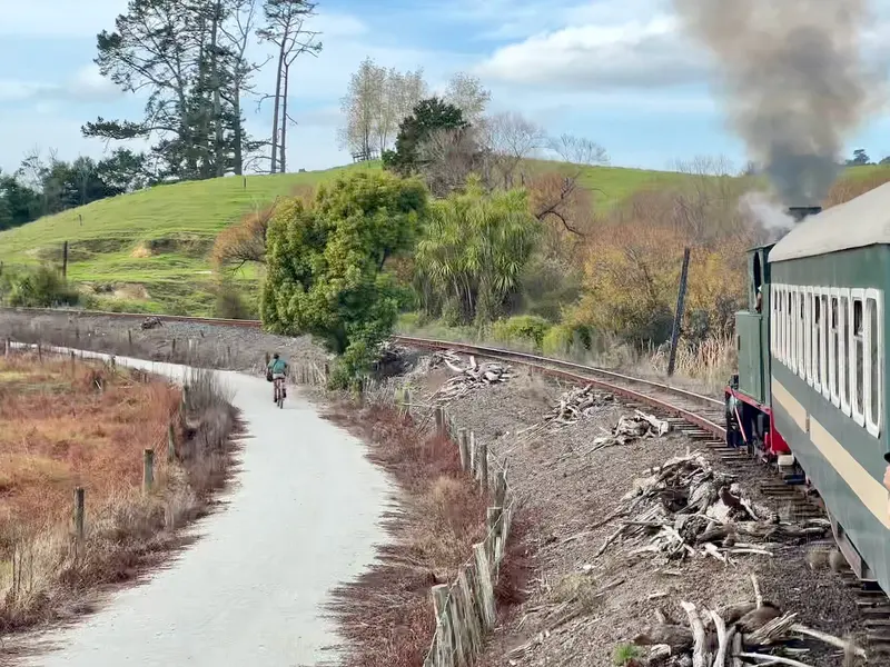
Photo: “Between Kawakawa and Taumarere the trail runs beside the railway” by Johnragla, CC0, via Wikimedia Commons
Trail at a glance
- Type
- Great Ride
- Region
- Northland
- Distance
- About 85–90 km
- Time
- 1–3 days
- Grade
- Grade 1–2 (one short Grade 3)
- Bookings
- Book train link ahead
- Managed by
- Ngā Haerenga NZ Cycle Trail
Overview
Pou Herenga Tai Twin Coast Cycle Trail is New Zealand's only coast-to-coast cycle trail. It crosses the Far North from Ōpua in the Bay of Islands to Hōreke on the Hokianga Harbour, past glittering coast, wetlands, native forest and rolling farmland, through towns rich in history and manaakitanga (hospitality). Combining the official day-ride distances, it's roughly 85–90 km coast to coast.
It's easy (Grade 1–2) almost all the way, on smooth rail trail, cycle paths, boardwalk, suspension bridges and quiet roads. The exception is a short Grade 3 section between Ōkaihau and Hōreke. Northland's sub-tropical climate makes it good for riding year-round.
Note: A 5 km section between Kawakawa and Ōpua is only accessible by the Bay of Islands Vintage Railway (bikes are carried). Otherwise, take the 17.7 km Ōpua–Whangae road route.
Highlights
- Coastal and cross-country scenery
- Rich Māori and colonial history, with bilingual information panels
- The Bay of Islands vintage train
- Kawakawa's Hundertwasser toilets, a famously quirky stop
- Kaikohe Pioneer Village and the Ngāwhā Springs hot pools, 7 km from Kaikohe
- Twin suspension bridges at Tuhi pā
- The Māngungu Mission Station and the peaceful Hokianga Harbour
Sections and day rides
| Ride | Distance | Grade | Time |
|---|---|---|---|
| Ōpua → Kawakawa (via train link) | 11 km | 1 | 1–1.5 hr |
| Kawakawa → Kaikohe | 34 km | 1–2 | 2–3 hr |
| Ōpua → Whangae Tunnel (return) | 5.6 km | 1 | 1 hr |
| Kaikohe → Ōpua (mostly downhill, with train) | 47 km | 1–2 | 3–5 hr |
| Kaikohe → Hōreke | 42 km | 2–3 | 3–5 hr |
The most popular direction is east to west, or downhill either way from Kaikohe, near the middle of the trail. Kaikohe → Hōreke follows the rail trail through a tunnel, along rivers and over a boardwalk to the harbour. Finish with a drink at the historic Hōreke Hotel.
Need to know
- Bike: A hybrid is fine, but a mountain bike is more comfortable on the Grade 3 Ōkaihau–Hōreke section. E-bikes are allowed.
- Weather: It can change between the two coasts in a single day, and the trail gets sticky after heavy rain.
- Food and water: Available in the towns along the way, but some cafés keep short hours off-season.
- Mobile coverage: Patchy between Kawakawa and Kaikohe. There's boosted free Wi-Fi in the Utukura Valley.
- Dogs: On a lead where allowed. Not allowed on the 12.5 km section from the Macadamia Orchard (Hōreke Road) to Harrison and Mangataraire roads, on Utukura No. 7 Inc land beside Hōreke Road, or on the section from Ngapipito Road to the suspension bridge. Horses need council consent.
Getting there
Auckland Airport is about 3.5 hours away, and Kerikeri Airport is 45 minutes away. InterCity serves Paihia and Kaikohe. You can hire bikes at Ōpua and Kaikohe. Paihia, Russell and Kerikeri are good bases, and group marae stays can be arranged through the trail. Book ahead for January to March.
Route map
The line shows the Twin Coast Cycle Trail as mapped in OpenStreetMap. It measures about 87.9 km, against an official distance of About 85–90 km. Use it to see where the route goes. It isn't for navigation, so carry the official map and check track status with Ngā Haerenga NZ Cycle Trail (opens in a new tab) before you set out.
Location data: OpenStreetMap contributors (ODbL 1.0).
Check before you go
Closures, slips, snow and booking changes happen often. Ngā Haerenga NZ Cycle Trail posts current alerts and bookings for the Twin Coast Cycle Trail on its official page.
Current alerts and bookings