Tongariro Alpine Crossing: Day Hike Guide, Bookings & Shuttles
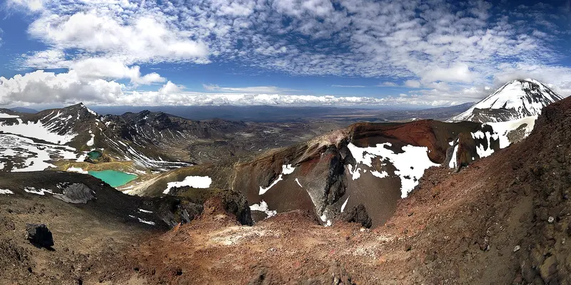
Photo: “Tongariro Alpine Crossing” by Jeffrey Pang, CC BY 2.0, via Wikimedia Commons
Trail at a glance
- Type
- Day walk
- Region
- Central North Island
- Distance
- 20.2 km one way
- Time
- 7–8 hr
- Grade
- Intermediate (summer)
- Bookings
- Free booking recommended, required for shuttles
- Managed by
- Department of Conservation
Overview
The Tongariro Alpine Crossing is one of New Zealand's best-known day hikes. It's a 20.2 km one-way trek across the volcanic landscape of Tongariro National Park: steaming vents, glacial valleys, old lava flows, Red Crater and the vivid Emerald Lakes (Ngā Rotopounamu). It takes 7–8 hours from November to April, and 9 hours in winter, with 1,196 m of elevation change.
DOC rates the fitness required as high, on a steep, undulating track. Most of it is open, exposed and uneven, and it's not recommended for children under 10.
Bookings, shuttles and parking
- Bookings are free and recommended for everyone using any part of the track. You must have a booking to use a shuttle or guided walk.
- Parking at the road ends is limited to 4 hours from Labour weekend to 30 April, and there's no hiker parking at Mangatepopo in summer. Take a shuttle. Arrange one through the i-SITEs in Ohakune, Taumarunui, Tūrangi or Taupō. Part of the shuttle fee, about $40, supports DOC conservation work.
- Don't park on the side of state highways.
- Nearby towns include Whakapapa (10.4 km), National Park (13.5 km), Tūrangi (36.7 km) and Taupō (86.5 km).
The route
- Mangatepōpō Valley (from 1,120 m): A gradual boardwalk climb. The first 5.4 km is shared with the easy Soda Springs Walk (2 hr return).
- Up to South Crater: A steady climb of about 350 m up a staircase.
- Red Crater (1,886 m): The highest point. Loose scree on the steep slopes is a major slip hazard, so take extra time and care.
- Emerald Lakes: A steep scree descent to the lakes.
- Blue Lake / Te Wai Whakaata o Te Rangihīroa: Then a long zig-zag descent with many steps, which is hard on knees, past views of Lakes Rotoaira and Taupō, into forest.
- Ketetahi Road (760 m): The end of the track.
Toilets are spaced every 1–2 hours. Carry 2–3 litres of water, as the water on the track isn't drinkable.
'Not Recommended Today' advisory
In summer, DOC issues a "Not Recommended Today" advisory at 6am when the Red Crater forecast exceeds set limits for wind, wind chill, rain or snow. It's signposted at Mangatepōpō and shown on the NIWA forecast. If it's applied, try Taranaki Falls or Tama Lakes instead. No advisories are issued from May to October, so judge the forecast yourself.
The 2025 fires and rāhui
In late 2025, two fires burned large areas around the start of the crossing. Expect blackened landscapes alongside regrowth. Ngāti Hikairo ki Tongariro have placed a 10-year restorative rāhui on the affected area. Stay on the track, clean your shoes and gear, and take your rubbish home.
Respecting the maunga
The mountains and all their waterways are sacred to Ngāti Hikairo ki Tongariro of Ngāti Tūwharetoa. Don't touch or enter any of the lakes. Manaaki Rangers greet visitors daily from November to April and share traditional stories. Tongariro became New Zealand's first national park in 1894, and in 1993 the first place inscribed on the World Heritage List as a cultural landscape.
Hazards
- Active volcano. Eruptions are unlikely but possible.
- Steam vents near the Emerald Lakes can cause severe burns, so stay on the track.
- Alpine weather at any time of year. Red Crater is at least 10°C colder than Taupō on a calm day.
Winter (May–October)
It becomes an expert route: snow, ice and avalanche terrain. You'll need a helmet, crampons, an ice axe and avalanche gear, plus the skills to use them. Shuttles generally don't run, so going with a guide is recommended.
Good to know
No dogs, no mountain bikes and no drones. For a multi-day version with nights in huts, see the Tongariro Northern Circuit.
Route map
The line shows the Tongariro Alpine Crossing as mapped in OpenStreetMap. It measures about 19.7 km, against an official distance of 20.2 km one way. Use it to see where the route goes. It isn't for navigation, so carry the official map and check track status with Department of Conservation (opens in a new tab) before you set out.
Location data: OpenStreetMap contributors (ODbL 1.0).
Check before you go
Closures, slips, snow and booking changes happen often. Department of Conservation posts current alerts and bookings for the Tongariro Alpine Crossing on its official page.
Current alerts and bookings