Timber Trail: Pureora Forest Great Ride and Suspension Bridges
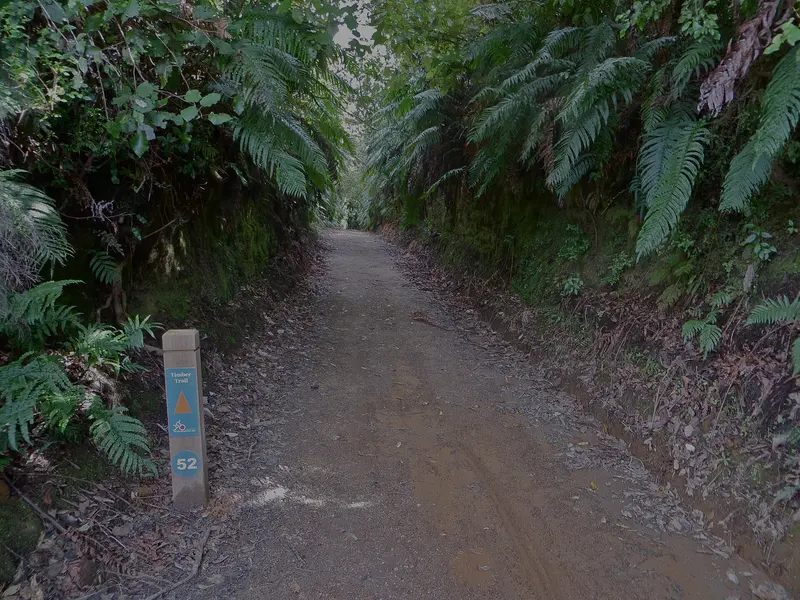
Photo: “Cutting on the Ellis and Burnand Ongarue tramway, now the Timber Trail” by Johnragla, CC BY-SA 3.0, via Wikimedia Commons
Trail at a glance
- Type
- Great Ride
- Region
- Waikato / King Country
- Distance
- 85 km
- Time
- 2 days
- Grade
- Grade 3 (intermediate)
- Bookings
- Book Piropiro stay and shuttles ahead
- Managed by
- Ngā Haerenga NZ Cycle Trail
Overview
The Timber Trail runs 85 km through Pureora Forest Park in the heart of the North Island. The park is a mix of exotic, regenerating and precious virgin forest, saved by environmental campaigners in the 1970s. The trail follows old logging roads and tramlines, linked by purpose-built singletrack and eight suspension bridges, three of them more than 100 m long. It's also part of Te Araroa.
It's Grade 3 (intermediate): generally wide and smooth, with sustained climbs, gravel roads and some mud after rain. The classic approach is a two-day ride from Pureora (north) to Ongarue (south), overnighting at Piropiro around halfway.
Highlights
- Huge ancient rimu and tōtara
- Mt Pureora's Cloud Forest and lookouts
- The Maramataha Suspension Bridge, 141 m long and 53 m high
- The Ongarue Spiral, the world's only bikeable railway spiral
- Logging relics, including a 1920s crawler tractor
- Birdlife including kākā, tūī and North Island robin
Two-day itinerary
| Day | Section | Distance | Time |
|---|---|---|---|
| 1 | Pureora → Piropiro Flats | 40 km | 4–7 hr |
| 2 | Piropiro Flats → Ongarue | 45 km | 4–7 hr |
Day 1 climbs through the virgin forest of the Pikiariki Ecological Area and the misty Cloud Forest to the trail's high point at 971 m. Then it's mostly downhill across the Hauhungaroa Range, over the 115 m Bog Inn and 109 m Orauaka suspension bridges, to Piropiro.
Day 2 climbs past the Maramataha bridge to the Ongarue tramway terminus, then follows the old tramway, mostly downhill, through rock cuttings where you may see glow-worms. It crosses the 89 m Mangatukutuku bridge and passes the Ongarue Spiral about 10 km from the end. Most riders finish at the Bennett Road hub, which has a shelter and toilets, for their shuttle.
Day rides
| Ride | Distance | Grade | Time |
|---|---|---|---|
| Crawler Tractor Loop (Pureora) | 7 km | 2 | 1–2 hr |
| Piropiro → Maramataha Bridge (return) | 10 km | 3 | 1.5–3 hr |
| Pureora → forest-edge shelter (return) | 16 km | 3 | 2–3 hr |
| Bennett Road → Ongarue Spiral (return) | 16 km | 3 | 2–3 hr |
| Full trail in a day | 85 km | 3 | 8–14 hr |
Need to know
- Bike: A well-maintained mountain bike, plus tools and spares. E-bikes are popular, but manage your battery over the long sections.
- Weather: It's sub-alpine near the summit and can be surprisingly cold, so carry layers and wet-weather gear.
- Food: Buy everything before you reach the trailheads. The lodges provide meals if you book them.
- Safety: Mobile coverage is patchy. It's good near the summit, and signs show other hotspots. Carry a personal locator beacon and a first-aid kit.
- Dogs: Only from Ngaherenga to Maramataha, with a DOC permit, generally for hunting. No horses.
Getting there and where to stay
Auckland, Taupō, Palmerston North and New Plymouth airports are all within about 3 hours. Taupō and Taumarunui are the main hubs for shuttles, bike hire and luggage transfers. Book Piropiro accommodation early for December to March. The DOC campsite there rarely fills. Fit riders can continue 26 km to Taumarunui on the Timber Trail Connection.
Route map
The line shows the Timber Trail as mapped in OpenStreetMap. It measures about 82.1 km, against an official distance of 85 km. Use it to see where the route goes. It isn't for navigation, so carry the official map and check track status with Ngā Haerenga NZ Cycle Trail (opens in a new tab) before you set out.
Location data: OpenStreetMap contributors (ODbL 1.0).
Check before you go
Closures, slips, snow and booking changes happen often. Ngā Haerenga NZ Cycle Trail posts current alerts and bookings for the Timber Trail on its official page.
Current alerts and bookings