Routeburn Track: Great Walk Guide, Harris Saddle, Huts & Transport
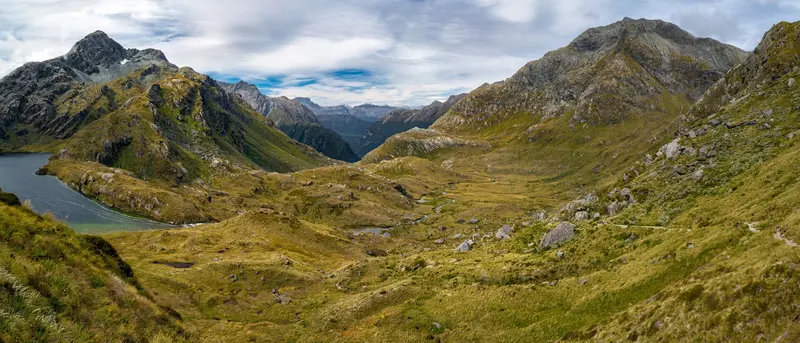
Photo: “Harris Saddle Routeburn Track New Zealand” by Ilya Grigorik, CC BY-SA 3.0, via Wikimedia Commons
Trail at a glance
- Type
- Great Walk
- Region
- Otago & Fiordland
- Distance
- 33 km one way
- Time
- 2–4 days
- Grade
- Intermediate (in season)
- Bookings
- Required 1 Nov – 30 Apr
- Managed by
- Department of Conservation
Overview
The Routeburn Track crosses the Southern Alps / Kā Tiritiri o te Moana between Mount Aspiring and Fiordland national parks. It runs 33 km one way, from the Routeburn Shelter near Glenorchy to The Divide on the Milford Road. You walk through beech forest, alpine meadows and past reflective tarns, with huge views over the Humboldt and Darran mountains.
You can walk it in either direction. Most people take 3 days and 2 nights, staying at Routeburn Falls and Lake Mackenzie huts. You can also link it with the Greenstone and Caples tracks to make a circuit.
Seasons
- Great Walks season (1 November 2026 – 30 April 2027): Bookings are required for all huts and campsites, there are more facilities, and DOC manages avalanche risk, which can last into December.
- May to October: Snow, ice, more than 32 avalanche paths, and bridges removed between Lake Mackenzie and Harris Saddle. Only for people with alpine skills and gear. Lake Mackenzie isn't safe to walk on when frozen.
Track sections
| Section | Time | Distance |
|---|---|---|
| Routeburn Shelter → Routeburn Flats Hut | 1.5–2.5 hr | 7.5 km |
| Routeburn Flats → Routeburn Falls Hut | 1–1.5 hr | 2.3 km |
| Routeburn Falls → Lake Mackenzie Hut | 4.5–6 hr | 11.3 km |
| Lake Mackenzie → The Divide | 4–5.5 hr | 12 km |
Highlights along the way:
- Harris Saddle / Tarahaka Whakatipu (1,255 m): The highest point on the track, with a day shelter and toilets
- Conical Hill side trip (1.5–2 hr return): Views down the Hollyford Valley to Lake McKerrow and the Tasman Sea
- The Hollyford Face: Known for its alpine plants and views of the Darran Mountains
- Earland Falls (174 m)
- Key Summit side trip (1–1.5 hr return): An alpine nature walk with tarns, bogs and birds
The Divide (532 m) is the lowest crossing of the Southern Alps in New Zealand. Lake Howden Hut was destroyed by storm damage in February 2020.
Huts and campsites
There are three huts: Routeburn Flats (20 bunks), Routeburn Falls (48) and Lake Mackenzie (50). There are also two campsites, at Routeburn Flats and Lake Mackenzie. All must be booked in the Great Walks season. Huts have heating, lighting, cooking facilities and flush toilets. Tap water isn't treated.
Day walks on the Routeburn
- Routeburn Nature Walk and the walk to Routeburn Flats, from the Glenorchy end
- Key Summit, Lake Howden and Earland Falls, from The Divide
- See our Key Summit guide.
Getting there
- Routeburn Shelter: 25 km from Glenorchy, on a partly unsealed road
- The Divide Shelter: 85 km from Te Anau, on the Milford Road
- The two ends are 325 km apart by road, so book shuttles or a vehicle relocation. Don't book a pickup that means leaving a hut before it's light.
Hazards
- Fiordland gets up to 9,000 mm of rain a year. Streams flood after heavy rain but drop quickly, so wait rather than cross.
- There are steep drop-offs along much of the track, and no-stopping rockfall zones on Conical Hill.
- Didymo has been found in creeks between Harris Saddle and Lake Mackenzie, so check, clean and dry your gear.
- There are wasps and sandflies. No mobile coverage. Not recommended for children under 10.
Good to know
No dogs. Check the Harris Saddle webcam for conditions before you go.
Route map
The line shows the Routeburn Track as mapped in OpenStreetMap. It measures about 31.5 km, against an official distance of 33 km one way. Use it to see where the route goes. It isn't for navigation, so carry the official map and check track status with Department of Conservation (opens in a new tab) before you set out.
Location data: OpenStreetMap contributors (ODbL 1.0).
Check before you go
Closures, slips, snow and booking changes happen often. Department of Conservation posts current alerts and bookings for the Routeburn Track on its official page.
Current alerts and bookings