Paparoa Track: Great Walk Guide for Hikers and Mountain Bikers
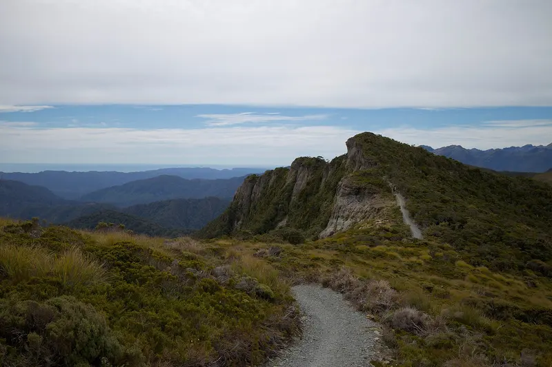
Photo: “Paparoa Track” by Mike and Lara Wolfe, CC0, via Wikimedia Commons
Trail at a glance
- Type
- Great Walk
- Region
- West Coast
- Distance
- 55 km one way
- Time
- 3 days walking, 2 riding
- Grade
- Intermediate / MTB Grade 4
- Bookings
- All 3 huts must be booked
- Managed by
- Department of Conservation
Overview
The Paparoa Track crosses the Paparoa Range in Paparoa National Park on the West Coast. It runs 55 km one way, from Smoke-ho car park near Blackball to Punakaiki, over alpine tops and through limestone karst and nīkau-filled rainforest. Hikers take 3 days and mountain bikers 2 days. It's one of only two Great Walks you can ride, along with the Heaphy.
The track is also a memorial. On 19 November 2010, 29 men died in an underground explosion at the Pike River Mine. The track was created in partnership with their families, DOC and Ngāti Waewae, the kaitiaki of the park, as a memorial to the men and a thank you to New Zealanders.
Highlights
- Pororari River Gorge: Dramatic limestone cliffs, beech forest and glades of nīkau palms
- Sunsets from Moonlight Tops Hut over the Tasman Sea
- The historic Croesus Track, built 1881–1899 for the gold mines above Blackball
- Views of Aoraki / Mt Cook from the tops on a clear day, and the Lone Hand rock formation near Pororari Hut
Track sections (walking)
| Section | Time | Distance |
|---|---|---|
| Smoke-ho car park → Ces Clark Hut | 4–5 hr | 10.3 km |
| Ces Clark Hut → Moonlight Tops Hut | 3 hr | 9.7 km |
| Moonlight Tops Hut → Pororari Hut | 5–7 hr | 19.1 km |
| Pororari Hut → Pororari River car park | 4–5 hr | 16 km |
The first section is the roughest, because it follows the historic Croesus Track. Side trip: Croesus Knob (1,204 m), 1 hr 10 min return, on a rough route that isn't suitable for bikes.
Trip options: For 2 nights, stay at Moonlight Tops and Pororari huts. For 3 nights, add Ces Clark Hut. Ces Clark to Pororari in one day (28.8 km) isn't feasible.
Huts and bookings
There are three huts: Ces Clark (16 bunks), Moonlight Tops (20) and Pororari (20). All three must be booked in advance. There are no campsites on the track, and you can't camp at the Smoke-ho car park, so book accommodation for the night before. Backcountry Hut Passes are accepted only at Ces Clark Hut, through a refund process.
Mountain biking
- Grade 4 (advanced), with long steep climbs, narrow track and obstacles. The climb to Ces Clark Hut is especially tough, and most riders walk some sections.
- No e-bikes and no night riding. Bikers must exit via the Punakaiki River valley to Waikori Road (17.1 km from Pororari Hut).
- The Pike29 Memorial Track can be combined with the ride: Smoke-ho to the Pike29 Memorial car park is 37 km (6.5–9.5 hr).
Getting there
- Smoke-ho car park: End of Blackball Road, 8 km north of Blackball. It's small and for day use only.
- Pororari River car park: SH6, 1.2 km north of Pancake Rocks, Punakaiki
- Waikori Road car park (bikes): SH6, 2.4 km south of Pancake Rocks
- Shuttle operators serve both ends. Cars have been broken into at all three car parks, so leave valuables elsewhere or park at your accommodation.
Hazards
- About 6,000 mm of rain a year, with snow, ice, fog and strong winds possible at any time of year
- Parts of the Pororari Valley flood in very heavy rain. Wait at Pororari Hut if conditions are bad.
- Landslides and rockfall, and ongaonga (tree nettle) in the Pororari Valley
- No mobile coverage on most of the track
History
The track passes the junction of the Cave Creek Memorial / Inland Pack Track, dedicated to the 13 students and a DOC officer who died when a viewing platform collapsed on 28 April 1995. The Inland Pack Track, built in 1867, was once a main route between Greymouth and Westport.
Route map
The line shows the Paparoa Track as mapped in OpenStreetMap. It measures about 51.3 km, against an official distance of 55 km one way. Use it to see where the route goes. It isn't for navigation, so carry the official map and check track status with Department of Conservation (opens in a new tab) before you set out.
Location data: OpenStreetMap contributors (ODbL 1.0).
Check before you go
Closures, slips, snow and booking changes happen often. Department of Conservation posts current alerts and bookings for the Paparoa Track on its official page.
Current alerts and bookings