Kaikōura Peninsula Walkway: Seals, Seabirds and Clifftop Views
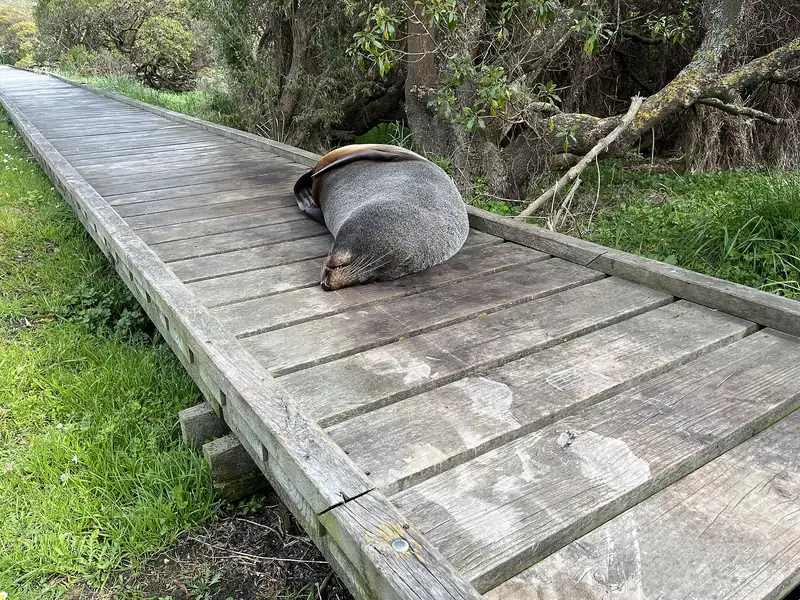
Photo: “Seal blocking a path, Kaikōura Peninsula, New Zealand” by Carlos Pacheco, CC BY 2.0, via Wikimedia Commons
Trail at a glance
- Type
- Day walk
- Region
- Canterbury
- Distance
- 200 m – 11.7 km
- Time
- 5 min – 3 hr
- Grade
- Easy to intermediate
- Bookings
- Not required
- Managed by
- Department of Conservation
Overview
The Kaikōura Peninsula Walkway loops around the limestone peninsula that juts about 4 km out from Kaikōura township. The Seaward Kaikōura Range rises behind it, snow-capped in winter. Along the way you'll see fur seals, seabirds, tidal platforms and historic pā and whaling sites, with information panels explaining it all.
The whole walkway takes about 3 hours, but you can do shorter sections. It's a Tohu Whenua heritage site.
Sections
| Section | Time | Distance |
|---|---|---|
| Town centre → Point Kean car park | 50 min | 4.4 km |
| Point Kean car park → viewpoint | 5 min | 200 m |
| Point Kean viewpoint → Whalers Bay viewpoint | 25 min | 1.5 km |
| Whalers Bay → South Bay viewpoint | 20 min | 1.1 km |
| South Bay viewpoint → South Bay car park | 15 min | 600 m |
| South Bay → town centre (via Toms Track) | 1 hr 5 min | 3.9 km |
Short options: From South Bay car park, a fully accessible path leads to Limestone Bay (5 min). There's also a 10-minute climb to the South Bay viewpoint.
Highlights
- Point Kean seals: Male fur seals often lounge in the car park, and females and pups are on the rock platforms. Stay at least 20 m away. They can bite, and the bites get infected.
- The waka-shaped lookout above Point Kean, with sea and mountain views
- Whalers Bay: A stairway down the old whalers' route to the shore. Return the same way. Don't climb the Sugarloaf. The clifftop above overlooks "Bird City", the largest red-billed gull colony in the South Island.
- The Hutton's shearwater colony, behind a 500 m predator-proof fence. The birds return at dusk.
- Tidal platforms at low tide, with oystercatchers, reef herons and shags. Little blue penguins are sometimes seen offshore.
History
Kaikōura means "eat crayfish", recalling Tama ki te Raki's meal here. The peninsula holds more than 800 years of Māori history, with at least 14 pā sites. Robert Fyffe set up the first shore-whaling station, Waiopuka, in 1843. Fyffe House (1860), built on whalebone piles, is open to the public.
Getting there
The walkway starts in Kaikōura township, about halfway between Picton (154 km) and Christchurch (183 km) on SH1. There's no scheduled public transport out to Point Kean.
Safety and rules
- Unfenced cliff edges. Stay on the track and supervise children.
- The peninsula is very exposed, and southerlies arrive fast. High tide can block the shoreline.
- No fires, no mountain bikes. Toilets are at Armers Beach, Point Kean and South Bay, but not on the clifftop.
- Dogs are allowed only on the town-to-Point Kean section (not in the car park), in South Bay Recreation Reserve, and on Toms Track. They aren't allowed on the clifftop walkway or the tidal platforms.
Check before you go
Closures, slips, snow and booking changes happen often. Department of Conservation posts current alerts and bookings for the Kaikōura Peninsula Walkway on its official page.
Current alerts and bookings