Heaphy Track: Great Walk Guide for Walkers and Mountain Bikers
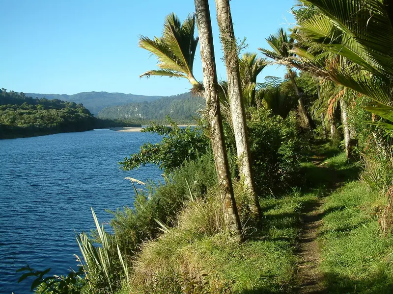
Photo: “HeaphyRiver” by Pierre Lavaurs, Public domain, via Wikimedia Commons
Trail at a glance
- Type
- Great Walk
- Region
- Nelson Tasman & West Coast
- Distance
- 78.4 km one way
- Time
- 4–6 days walking
- Grade
- Intermediate tramping track
- Bookings
- Huts and campsites must be booked year-round
- Managed by
- Department of Conservation
Overview
The Heaphy Track is the longest of New Zealand's Great Walks on foot, at 78.4 km one way through Kahurangi National Park. It links Golden Bay with the West Coast near Karamea, and the scenery changes completely along the way: beech forest, the vast open tussock of the Gouland Downs, then nīkau-palm forest and the roaring surf of the Tasman Sea.
Along with the Paparoa Track, it's one of only two Great Walks you can mountain bike, from 1 May to 30 November. Walkers usually take 4–6 days. Fit, experienced riders take 2 days.
The track has reopened as a through route with a new bridge across the Heaphy River.
Track sections
| Section | Walking | Biking | Distance |
|---|---|---|---|
| Brown Hut → Perry Saddle Hut | 5 hr | 2.5–3.5 hr | 17.5 km |
| Perry Saddle → Gouland Downs Hut | 2 hr | 1–2 hr | 7 km |
| Gouland Downs → Saxon Hut | 1 hr 30 min | 1–2 hr | 5.4 km |
| Saxon → James Mackay Hut | 3 hr | 2–3 hr | 11.8 km |
| James Mackay → Heaphy Hut | 6 hr | 2.5–4.5 hr | 20.5 km |
| Heaphy Hut → Kohaihai | 5 hr | 3–4 hr | 16.2 km |
Highlights
- Flanagans Corner (915 m): The highest point on the track, about 30 minutes before Perry Saddle Hut
- Gouland Downs: Open tussock, limestone arches, the famous "boot pole" at Cave Brook, and great spotted kiwi (roroa)
- James Mackay Hut: Views 15 km west to the Tasman Sea and the Heaphy River mouth
- Lower Heaphy: Nīkau palms, and two huge rātā by the Heaphy swing bridge that may be among the oldest and largest in New Zealand
- Heaphy River mouth: Where two pounamu (greenstone) trails met. Archaeology shows Māori occupation here going back about 500 years.
- Ōparara Arch: A 35-million-year-old limestone arch, 30 minutes' walk off the road between Kohaihai and Karamea
Huts and bookings
There are 6 huts and 9 campsites, and all must be booked in advance all year. The huts have bunks, mattresses, heating, toilets and basic cooking facilities, and a DOC ranger may be there. Campers can't use the hut facilities. Fees are charged per person per night, with higher international rates in summer. Day walks are free.
Mountain biking the Heaphy
- Open 1 May – 30 November, daylight only (half an hour before sunrise to half an hour after sunset), to protect nocturnal great spotted kiwi and giant Powelliphanta land snails
- Grade 4 (advanced). This is "a tough ride, not a cycle trail".
- Groups of no more than 6 riders. No e-bikes. No bikes inside huts or on porches.
- Kea at James Mackay Hut chew bike seats and brake lines, so take your seat inside and cover the hoses.
Getting there
- Brown Hut (Golden Bay end): 156 km from Nelson (about 2 hr 25 min) via SH60 to Collingwood, then 28 km up the Aorere Valley
- Kohaihai (West Coast end): 110 km from Westport (about 1 hr 45 min) via SH67 to Karamea, then 15 km north
- Bus, taxi, vehicle-relocation and small-plane services link both ends. Many walkers fly back to their starting point. Some operators don't run in winter.
Hazards
- Rainfall averages over 4,000 mm a year. Streams rise fast. Between Lewis Shelter and Heaphy Hut, floods can reach 1.5 m over the track, so wait at a hut or shelter until it's safe.
- A short wetland section on Mackay Downs becomes impassable in extreme rain.
- Large waves can wash over the coastal section near high tide, so check the tide charts. Don't swim at the Heaphy or Kohaihai river mouths, where the currents are dangerous.
- Treat drinking water because of the giardia risk. Mobile coverage is poor.
Good to know
No dogs. Mountain biking is allowed only in season and on the formed route. In a long or strong earthquake, move to higher ground immediately, because of the tsunami risk.
Route map
The line shows the Heaphy Track as mapped in OpenStreetMap. It measures about 73.2 km, against an official distance of 78.4 km one way. Use it to see where the route goes. It isn't for navigation, so carry the official map and check track status with Department of Conservation (opens in a new tab) before you set out.
Location data: OpenStreetMap contributors (ODbL 1.0).
Check before you go
Closures, slips, snow and booking changes happen often. Department of Conservation posts current alerts and bookings for the Heaphy Track on its official page.
Current alerts and bookings