Around the Mountains Cycle Trail: Walter Peak to Kingston Guide
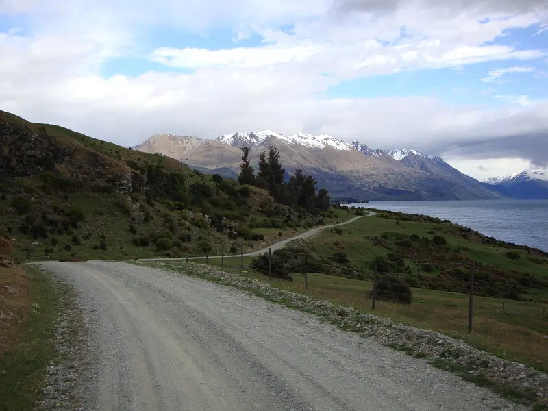
Photo: “Mt Nicholas Beach Bay Road” by Schwede66, CC BY-SA 3.0, via Wikimedia Commons
Trail at a glance
- Type
- Great Ride
- Region
- Southland
- Distance
- About 186 km
- Time
- 4–5 days
- Grade
- Grade 1–3
- Bookings
- Book boat and shuttles ahead
- Managed by
- Ngā Haerenga NZ Cycle Trail
Overview
The Around the Mountains Cycle Trail loops through Southland's rural heartland and the mountain country southwest of Queenstown. It usually starts with a cruise across Lake Wakatipu on the vintage TSS Earnslaw to Walter Peak Station. From there it heads into the wild Von Valley, past the glacier-carved Mavora Lakes, around the Eyre Mountains (Taka Ra Haka), and through the Southland towns of Mossburn, Lumsden, Athol and Garston, finishing at Kingston on Lake Wakatipu.
The section distances add up to about 186 km. Most reasonably fit riders take 4–5 days. The trail is mostly Grade 1–2 on wide, well-graded paths, but the remote Walter Peak–Mavora section is Grade 3.
Highlights
- The TSS Earnslaw cruise and historic Walter Peak Station
- The golden tussock of the Von Valley and the remote, wild atmosphere
- Mavora Lakes, a Lord of the Rings filming location
- Country hospitality in Mossburn, Lumsden, Athol and Garston, "New Zealand's most inland town"
- The "Golden Gate" wooden suspension bridges near Athol
Trail sections (anti-clockwise, the recommended direction)
| Section | Distance | Grade | Time |
|---|---|---|---|
| Walter Peak Station → Mavora Lakes | 50 km | 3 | 5–6 hr |
| Mavora Lakes → Centre Hill Shelter | 29 km | 3 | 2–3 hr |
| Centre Hill Shelter → Mossburn | 24 km | 2 | 2–3 hr |
| Mossburn → Lumsden | 20 km | 2 | 1.5–2.5 hr |
| Lumsden → Athol | 33 km | 2 | 3–4 hr |
| Athol → Kingston | 30 km | 2 | 2.5–3 hr |
Starting at Walter Peak makes the most of the prevailing winds and terrain. The gravel road from Mavora Lakes to Centre Hill can be dusty and busy in summer, and many riders take a shuttle for that stretch.
Day rides
- Lumsden → Athol (33 km, 3–4 hr): Old railway line beside the Oreti River, with a café and gallery stop at Five Rivers.
- Athol → Kingston (30 km, 2.5–3 hr): Past the Golden Gate bridges, Garston and historic Fairlight Station.
Need to know
- There are no services between Walter Peak and Mossburn, about 100 km, and no mobile coverage for most of that stretch. Carry all your food and water.
- E-bikes: Allowed, but Walter Peak to Mossburn is about 100 km with no charging, which exceeds most batteries. Plan spare capacity.
- Bike: A well-maintained mountain bike. Carry a spare tube and tools for the remote section.
- Camping: The basic DOC campsite at Mavora Lakes South has water (boil or treat it) and toilets. Pay in cash, and expect sandflies.
- Fords: There are two fords between Mt Nicholas Station and Mavora Lakes, which can be impassable after heavy rain.
- Season: Most popular from October to May. Summer is hot, and snow can block sections in winter.
- Dogs and horses: Not allowed.
Getting there and logistics
- Queenstown is the hub. Boats across Lake Wakatipu are run by Real Journeys, Southern Discoveries and Queenstown Water Taxis.
- The Southland towns are on the Southern Scenic Route, served by InterCity. Invercargill Airport is about an hour from Lumsden.
- Book tours, shuttles and accommodation ahead, especially from December to April. Shuttles don't run to a fixed schedule.
Route map
The line shows the Around the Mountains Cycle Trail as mapped in OpenStreetMap. It measures about 183.2 km, against an official distance of About 186 km. Use it to see where the route goes. It isn't for navigation, so carry the official map and check track status with Ngā Haerenga NZ Cycle Trail (opens in a new tab) before you set out.
Location data: OpenStreetMap contributors (ODbL 1.0).
Check before you go
Closures, slips, snow and booking changes happen often. Ngā Haerenga NZ Cycle Trail posts current alerts and bookings for the Around the Mountains Cycle Trail on its official page.
Current alerts and bookings