Motukorea / Browns Island: Auckland's Island Regional Park
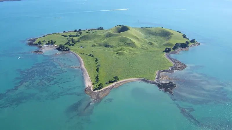
Photo: “Motukorea 2009” by Bruce Hayward, CC BY-SA 4.0, via Wikimedia Commons
Park at a glance
- Region
- Auckland
- Location
- Inner Hauraki Gulf (boat access only)
- Managed by
- Auckland Council
- Dogs
- No dogs
- Camping
- No
Overview
Motukorea / Browns Island is a small volcanic island in the inner Hauraki Gulf, close to the Tāmaki Estuary and the eastern bays. Seen from above, it shows a well-preserved crater and the remains of scoria cones. It's one of the clearest views of how Auckland's volcanic field shaped the gulf.
The island is one of more than 50 islands in the Hauraki Gulf Marine Park. It became Auckland's newest regional park, and its first island public reserve, in February 2018.
Getting there
Motukorea is accessible only by water. No public ferry runs to it, so you'll need your own boat, kayak or a charter. Kayaks need calm conditions and some experience, because the gulf can turn quickly. Check the marine forecast and tides, wear a life jacket and tell someone your plans.
What to expect
Auckland Council doesn't list any facilities for the island, so plan as if there are no toilets, drinking water or shelter. Bring everything you need and take everything away with you, including rubbish. This is a place for a quiet landing, a walk around the volcanic landscape and views back to Rangitoto and the city.
Dogs on Motukorea
Dogs are prohibited at all times on the island and its foreshore.
Good to know
- Fire ban: A prohibited fire season currently covers all islands in the Hauraki Gulf. All outdoor fires are banned and existing fire permits are suspended. See checkitsalright.nz for what you can and can't do.
- The island is smokefree, like all Auckland regional parks.
- There's no camping on the island.
Where is Motukorea / Browns Island?
The pin marks: Centre of the park area (-36.8306, 174.8944). It isn't an entrance or car park, so check the council's park page for access points before you go. Plan a route on OpenStreetMap (opens in a new tab).
Location data: Auckland Council Park Extents (CC BY 4.0); OpenStreetMap contributors (ODbL 1.0).
Check before you go
Track closures, gate times, fire bans and storm damage change often. Auckland Council posts current alerts for Motukorea / Browns Island on its official park page.
Current park alerts