Mahurangi Regional Park: Sullivans Bay, Scott Point & Sadler Point
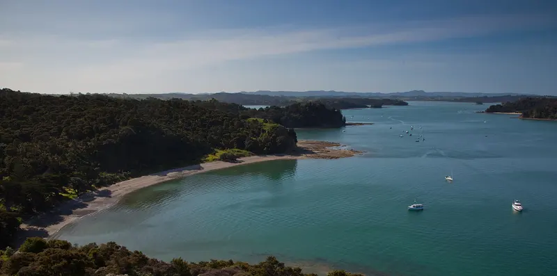
Photo: “Otuawaea Bay in the Mahurangi Harbor” by russellstreet, CC BY-SA 2.0, via Wikimedia Commons
Park at a glance
- Region
- Auckland
- Location
- Mahurangi Harbour, near Warkworth
- Managed by
- Auckland Council
- Dogs
- Dogs in some areas
- Camping
- Yes, see Camping section
Overview
Mahurangi Regional Park spreads around the mouth of the Mahurangi Harbour, north of Auckland. It offers sheltered bays, native bush, open pasture and historic sites, and it's a favourite stop for boaties all year round. Auckland Council manages it in three parts:
- Mahurangi West: Sullivans Bay (Otarawao Bay), Mita Bay (Otuawao Bay) and the Cudlip Point and Tungutu lookouts
- Mahurangi East – Scott Point: Scotts Landing, Scott Homestead, Baileys Cottage and the low-tide walk to Casnell Island (Maunganui)
- Mahurangi East – Sadler Point: Big Bay and Lagoon Bay, which you can only reach by boat
Te Muri Regional Park adjoins Mahurangi West to the south, across the Te Muri estuary.
Road closure: Mahurangi West (until 19 December 2026)
Vehicle access to Mahurangi West is closed because of a slip on Mahurangi West Road after heavy rain in January. The road is due to reopen on 19 December 2026. Until then you can only reach the park by boat. The closure affects Sullivans Bay and Mita Bay campgrounds, the Mahurangi CSC parking area, Te Muri Regional Park, Te Muri Beach campground and Puhoi Cottage.
Getting there and opening hours
- Mahurangi West: 192 Ngarewa Drive, Mahurangi West. There are about 1 km of unsealed road, a top car park (25 spaces) and Sullivans Bay car park (40). The vehicle gate is open 6am–9pm during daylight saving and 6am–7pm the rest of the year.
- Scott Point: 2 Ridge Road, Mahurangi East, with a one-lane tidal concrete boat ramp and jetty at Scotts Landing
- Sadler Point: Boat access only. There's a dinghy ramp at Ngaio Bay.
Walks and tracks
| Track | Time | Distance | Notes |
|---|---|---|---|
| Mita Bay Loop Track | 2 hr | 2 km | |
| Cudlip Point Loop Track | 90–120 min | 3 km | Prams possible |
| Te Muri Loop | 3 hr | 3 km | Crosses to Te Muri |
| Scott Point boardwalk | Short | – | Good for buggies |
At low tide you can walk across the rocks to Pudding Island (Mahurangi West) or to Casnell Island (Scott Point). Watch the incoming tide.
Things to do
Sullivans Bay
Sullivans Bay is the main arrival area. You can swim at all tides, and there are beachside picnic spots and drinking fountains. Paddle round to Mita Bay or Te Muri Beach, or, if you're experienced, head out across Kawau Bay to Motuora Island.
Scott Homestead
The historic Scott Homestead at Scotts Landing can be hired for daytime events (8am–10pm), along with its grounds. Scarlet pōhutukawa put on a spectacular show at Scott Point in summer.
Big Bay (Sadler Point)
Big Bay is a white sandy beach you can only reach by boat. Lagoon Bay is shallow, muddy and very tidal, and isn't good for swimming. Part of Sadler Point's east coast is in the Kawau Bay high protection area, where you can't fish or take seafood.
Land-based anglers try for kahawai and snapper from the rocks (MPI rules apply). Birdwatchers can spot little blue penguins, dotterels, reef herons and shining cuckoos. There's a 20-marker orienteering course across Mahurangi and Te Muri.
Dogs at Mahurangi
- Scott Point: On a leash across the park, beach and foreshore. Prohibited at Scott Homestead, Ferguson House and Baileys Cottage. DOC doesn't allow dogs on the neighbouring Mahurangi Scenic Reserve or Casnell Island.
- Mahurangi West: On a leash at Mita Bay beach and on the Mita Bay Loop Track from 1 December to 30 June. Prohibited during lambing (1 July to 30 November) and everywhere else, including Sullivans Bay, the Tungutu and Cudlip Point tracks, roads and car parks. Nearby Opahi Bay allows dogs on a leash year-round.
- Sadler Point: Prohibited at all times
Camping and places to stay
- Sullivans Bay campground: Vehicle-based and very popular, so book early. Self-contained motorhomes can use the CSC area for one night, or three when the campground is closed.
- Mita Bay and Te Muri campgrounds: Back-country, walk-in or boat-in only
- Lagoon Bay campground (Sadler Point): Boat access only, with a long-drop toilet
- Baches: Baileys Cottage (Scott Point), and Big Bay Bach and Vine House (Sadler Point)
There's no public water supply at Scott Point. Mobile coverage is poor across most of Mahurangi.
Where is Mahurangi Regional Park?
The pin marks: Centre of the park area (-36.4949, 174.7366). It isn't an entrance or car park, so check the council's park page for access points before you go. Plan a route on OpenStreetMap (opens in a new tab).
Location data: Auckland Council Park Extents (CC BY 4.0); OpenStreetMap contributors (ODbL 1.0).
Check before you go
Track closures, gate times, fire bans and storm damage change often. Auckland Council posts current alerts for Mahurangi Regional Park on its official park page.
Current park alerts