Hūnua Ranges Regional Park: Hūnua Falls, Tracks & Camping
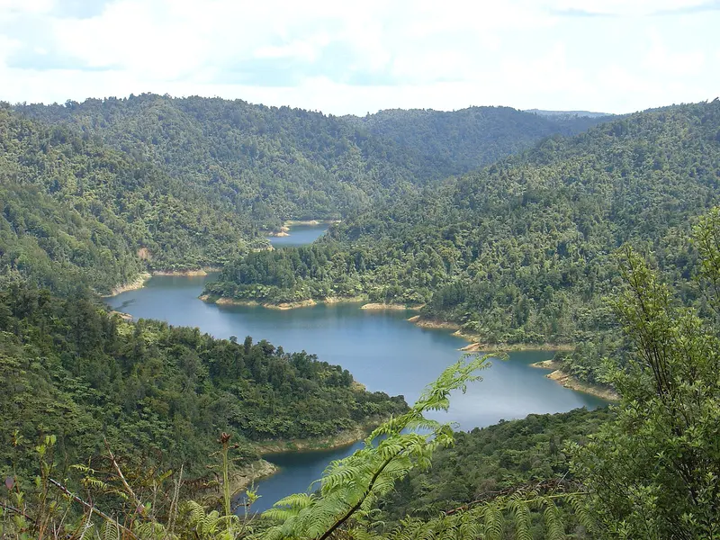
Photo: “Mangatangi-Reservoir-Hunua-Ranges” by WhiteCat at English Wikipedia, Public domain, via Wikimedia Commons
Park at a glance
- Region
- Auckland
- Location
- Hūnua, south-east Auckland
- Managed by
- Auckland Council
- Dogs
- Dogs in some areas
- Camping
- Yes, see Camping section
Overview
Hūnua Ranges Regional Park is the big bush playground of south-east Auckland, covering roughly 178 square kilometres. It protects the largest native forest in the Auckland region: bush-clad ranges cut by streams, with waterfalls and four large water-supply reservoirs (Cosseys, Wairoa, Mangatāwhiri and Mangatangi).
Most day visitors come for Hūnua Falls, a short walk from the car park. Trampers, mountain bikers and horse riders can spend days exploring the backcountry. Parts of the park continue into the Waikato region.
Getting there and opening hours
- Main entrance: Falls Road, Hūnua, for Hūnua Falls. Other areas are reached via Moumoukai Road (Wairoa, Cosseys) and the Mangatāwhiri valley.
- Vehicle gates: 6am–9pm during daylight saving and 6am–7pm the rest of the year
- Roads: The access roads are unsealed. Mangatangi Hill Road is a working Watercare road, so drive with care.
Closures and notices
Closures change often, so check the official park page for the current status before you go.
- The Hūnua Traverse (northern section) is closed on weekdays from 14 September 2026 for forestry works. The closure covers everything reached from Otau Mountain and Moumoukai Hill roads through to the Waterline and Keeney roads intersection. Some sections open at weekends and on public holidays. See the Hūnua Traverse website for the closure map.
- Cossey Access Track has a detour around a large slip near the top. The track is open, but use the signed road route.
- Kauri dieback: Large sections of the ranges are closed to protect kauri. Clean your gear at every hygiene station.
Walks and tracks
| Track | Time | Distance |
|---|---|---|
| Hūnua Falls Track | 15 min | 0.8 km |
| Hūnua Falls Upper Lookout Walk | 30 min | 0.8 km (prams OK) |
| Cossey Gorge Track | 30 min | 2.1 km |
| Suspension Bridge Loop | 90 min | 3.5 km |
| Cossey–Massey Loop Walk | 3 hr | 8.3 km |
| Wairoa Loop Track | 3 hr | 6.5 km |
| Mangatangi Trig Track | 3 hr | 3.9 km |
| Pukapuka Track | 4 hr | 6.4 km |
| Mangatangi Ridge Track | 6 hr | 9.1 km |
| Workman Track | 6 hr | 10.2 km |
All four dams can be reached with a pram from their car parks. Most other walks aren't suitable for prams. The lower Hūnua Falls lookout involves a few steps.
Things to do
Hūnua Falls
Hūnua Falls is the park's best-known spot, about two minutes on foot from the car park. A short loop walk climbs through the forest to lookouts above it. There are picnic tables nearby. Swimming at the falls is not recommended because of the many safety risks at this site.
Mountain biking
The Hūnua Ranges are one of Auckland's main mountain bike areas. The Mangatāwhiri Challenge Track (about 15 km) is a well-known loop, and there are bike-only trails such as Freaky Styley, Pipeline and Fred Flintstone, plus a national downhill course. Shared roads like Waterline, Workman and Repeater link up longer rides.
Tramping and the Hūnua Traverse
The Hūnua Traverse is a multi-day tramping route through the ranges. Longer tracks like Mangatangi Ridge and Workman take most of a day. Carry a map, tell someone your plans and check track status before you go.
Horse riders have designated trails through the lower Mangatāwhiri valley. You'll need a horse-riding pass and must clean your gear at the Watercare gate. Trout fishing is possible on the Wairoa River below the falls; check the rules with angling clubs. Drones are not allowed anywhere in the park.
Dogs in the Hūnua Ranges
Dog rules depend on where you are:
- On a leash: The south-western tracks, including Pukapuka, Mangatangi Trig, Cossey Gorge, Wairoa–Cossey, Massey, Suspension Bridge and Wairoa Loop. Also the Hūnua Falls Loop Walk, the Hūnua Traverse, car parks, and shared roads such as Waterline, Workman and Repeater.
- Prohibited: Around all reservoirs; the Kōkako Management Area, including Kohukohunui, Ernie's, Mangatangi Ridge, Rata Ridge and Mine Road tracks; all campgrounds; mountain-bike-only tracks; and farm paddocks during lambing (1 July to 30 November).
Camping and places to stay
Hūnua has five bookable campgrounds: Lower Mangatāwhiri, Upper Mangatāwhiri, Mangatangi Trig, Piggott's and Repeater. There's also overnight vehicle parking at Hūnua Falls and Upper Mangatāwhiri, including CSC areas. Kōkako Lodge, an outdoor education centre, takes group bookings through its own website.
Where is Hūnua Ranges Regional Park?
The pin marks: Centre of the park area (-37.0668, 175.1804). It isn't an entrance or car park, so check the council's park page for access points before you go. Plan a route on OpenStreetMap (opens in a new tab).
Location data: Auckland Council Park Extents (CC BY 4.0); OpenStreetMap contributors (ODbL 1.0).
Check before you go
Track closures, gate times, fire bans and storm damage change often. Auckland Council posts current alerts for Hūnua Ranges Regional Park on its official park page.
Current park alerts