East Harbour Regional Park: Pencarrow Lighthouse, Baring Head & Eastbourne Bush
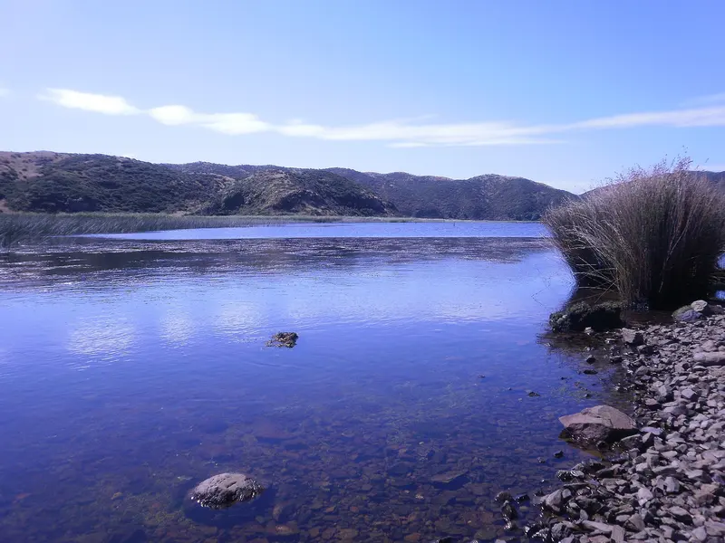
Photo: “Lake Kohangatera” by Rudolph89, CC BY-SA 3.0, via Wikimedia Commons
Park at a glance
- Region
- Wellington
- Location
- Eastbourne to Baring Head
- Managed by
- Greater Wellington Regional Council
- Dogs
- Dogs in some areas
- Camping
- No
Overview
Like a jigsaw, East Harbour Regional Park is made up of three separate areas on the eastern side of Wellington Harbour:
- The Northern Forest: Bush-clad hills from Eastbourne to Wainuiomata, with towering northern rātā, beech forest and the popular Butterfly Creek picnic area
- Parangarahu Lakes: South of Eastbourne along the Pencarrow Coast Road. It includes Lakes Kohangapiripiri and Kohangatera and the Pencarrow lighthouses, and is co-managed with the Port Nicholson Block Settlement Trust (Taranaki Whānui).
- Baring Head / Ōrua-pouanui: Reached from Wainuiomata, with rugged coast, an intact 1935 lighthouse complex and sweeping Cook Strait views
There's no public access between the Parangarahu Lakes and Baring Head without the private landowners' permission. Contact the ranger at least a week ahead.
A lot of history
Māori have long occupied this coast, with archaeological sites around Fitzroy Bay and the lakes. Baring Head was an important mahinga kai (food-gathering area). Before the Remutaka Hill road opened in 1856, the Pencarrow coast track was the only route between Wellington and the Wairarapa. The magnitude 8.2 earthquake of 1855 lifted the shoreline by about two metres and made it far easier to travel.
Pencarrow Lighthouse was New Zealand's first permanent lighthouse, opened on 1 January 1859. Its keeper, Mary Jane Bennett, was the country's first and only woman lighthouse keeper. Up to 21 shipwrecks have been recorded along this coast. In 1968, 49 of the 53 people who died in the Wahine disaster were cast onto the Eastbourne shore.
Getting there
- Ferry: The East by West ferry runs from Queens Wharf to Days Bay, passing Matiu/Somes Island, for the Northern Forest.
- Bus: Routes 81 and 83 run to Days Bay and Eastbourne. Stay on to the last Muritai Road stop for the Pencarrow Coast Road.
- Northern Forest entrances: Eastbourne (Korohiwa Bus Barn, Kowhai Street, Muritai Road), Days Bay (Williams Park), York Bay, Lowry Bay, Point Howard, Wainuiomata Hill Road and several Wainuiomata streets
- Pencarrow: Walk or bike from Burdans Gate at the south end of Eastbourne. Bikes are for hire at the Bike Shed nearby.
- Baring Head: Off Coast Road, Wainuiomata
Walks and rides
| Area | Track | Distance / time | Grade |
|---|---|---|---|
| Northern Forest | Days Bay Loop | 3.5 km / 1 hr 45 min | Medium |
| Northern Forest | Lowry Bay Loop | 5 km / 1 hr 40 min | Easy |
| Northern Forest | Butterfly Creek Loop | 7.4 km / 2.5 hr | Medium |
| Northern Forest | The Traverse | 13 km / 5 hr | Hard |
| Parangarahu Lakes | Burdans Gate to Lower Lighthouse | 6.7 km one way | Easy (flat gravel road) |
| Parangarahu Lakes | Lighthouse Loop | 3.6 km / 1 hr | Medium |
| Parangarahu Lakes | Cameron Ridge Loop | 4.2 km / 1 hr 15 min | Medium |
| Baring Head | Oxbow Loop | 2.2 km / 35 min | Easy |
| Baring Head | Lighthouse via Road | 3.2 km / 50 min one way | Medium |
| Baring Head | Grand Loop | 7 km / 3 hr | Hard |
The coastal ride to Pencarrow is flat but very exposed. Expect strong headwinds, and bring food, water and warm layers because there's no shelter. Mountain bikers can ride the Rātā Ridge track (6 km, hard) from Wainuiomata Hill to Lowry Trig.
Things to do
Baring Head lighthouse complex
Baring Head has New Zealand's only lighthouse compound still in its original condition. The 12 m lighthouse sits 87 m above sea level and was built in 1935. The complex and its WWII structures were added to the New Zealand Heritage List in 2023. A Storytelling Hub in the old powerhouse covers the area's history and gives shelter on a windy day.
Bouldering at Baring Head
Baring Head is known as the birthplace of New Zealand bouldering. Greywacke boulders and walls up to 8 m rise straight off the beach. It's also a popular spot for hang gliding and paragliding, which is managed through the Wellington Hang Gliding and Paragliding Club.
Butterfly Creek
This bush valley has been a picnic favourite since the 1930s, when Depression-era workers cut the access tracks. You can swim in Butterfly Creek itself, but not in Gollans Stream nearby.
No swimming in the two Parangarahu lakes. Swimming isn't recommended on beaches south of Burdans Gate either, because the currents are strong.
Dogs at East Harbour
- Northern Forest: Welcome on a leash
- Pencarrow Coast Road (Burdans Gate to the lower lighthouse): On a leash from 31 October to 31 July, and no dogs from 1 August to 30 October
- Parangarahu Lakes and Baring Head: No dogs
Places to stay
You can stay in two restored 1935 lightkeeper's cottages in the Baring Head complex. They feel remote, but they're only about an hour from downtown Wellington. One has level access and an accessible bathroom.
Good to know
There are no facilities in the Northern Forest, fires are prohibited, and the south-coast weather can turn fast. Gollan's Valley Station currently has no public access while restoration is planned. Quad bikes and trail bikes aren't allowed.
Where is East Harbour Regional Park?
The pin marks: Centre of the park area (-41.2829, 174.9306). It isn't an entrance or car park, so check the council's park page for access points before you go. Plan a route on OpenStreetMap (opens in a new tab).
Location data: OpenStreetMap contributors (ODbL 1.0).
Check before you go
Track closures, gate times, fire bans and storm damage change often. Greater Wellington Regional Council posts current alerts for East Harbour Regional Park on its official park page.
Current park alerts